Real-time data on eroding riverbanks is available now with new type of soil sensors – helping to build models for future river management
The freshwater scientists from Aalto university have recently started a fruitful cooperation with a Finnish company called Soil Scout, manufacturing soil sensors mainly for agricultural purposes. Erik van Rooijen has now published the first experiences and lessons to learn in using the same sensors for tracking river bank erosion.
One of the first things that catches your eye is that Van Rooijen’s article contains an extensive and rather interesting table on all possible ways that have been used in the past for studying riverbank erosion. “Yes, big part of the job was going through the literature and basically identifying what had been done before in terms of measuring devices, what has been used for specifically temperature, soil moisture and movement of soil in the bank. Identifying how all the previous measurement approaches worked, their advantages and disadvantages, and then comparing them to the soil sensors that we have.” Van Rooijen explains.
Read van Rooijen’s article at: https://onlinelibrary.wiley.com/doi/10.1002/esp.5640
The brief history of soil movement research
If we go back to the 90’s, the soil movement measurements were quite simple: basically one could put a stick in the ground and see when the stick has moved, or put a painted pebble on the ground and every time you go back you see where the pebble has moved to. The methods have become slightly more sophisticated these days, more recently drones have been used to determine the soil movement, by creating a complete 3D image of the field site and making another drone flight couple of months later, to see what has changed. Another newer method is to put pins with photovoltaic cells, or solar cells, in the ground, measure how many of them are getting sunlight and then determining if the situation changes.
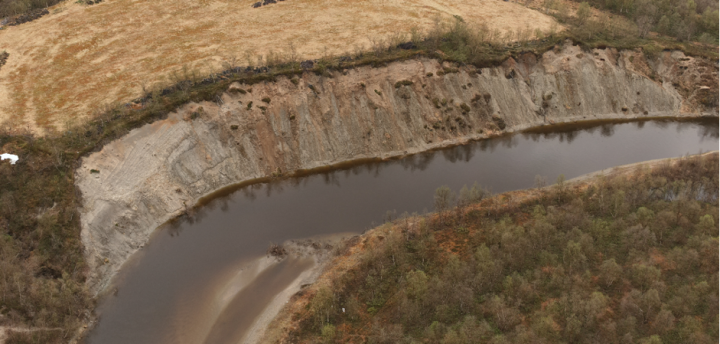
The sensors van Rooijen uses now are unique, as to his knowledge this is the first time that scientists are getting real time data on river bank erosion. “The advantage is also that you get soil movement, moisture and temperature at one go, while previously you needed a separate measuring approach. I would say these are the two main advantages compared to the previous methods, and maybe also the temporal resolution, meaning that we get a data point every 20 minutes. With the drone flights it’s much less, one would maybe do one drone flight every couple of months, although the spatial resolution and extent is higher as you cover a large area with the drone, while the sensors are point measurements. A combination of these two methods would be really good, as then you have both the wide spatial extent and temporal resolution.”

Many consequences of riverbank erosion
Thinking of the bank erosion, one may think of collapsing buildings and loss of land, but this is the narrow scope of thinking – in Finland for example the phosphorus runoff caused by bank erosion can be locally an important factor for eutrophication and algae blooms in water basins. The other really important factor is the amount of sediment being moved by the river – sedimentation has consequences for example for erosion happening elsewhere in the river and inland shipping.
Many of the large European rivers have extensive and economically important inland shipping. Modeling the sedimentation there with a digital twin could be important – but modeling such large rivers is expensive and very complicated and we are not there yet. “Maybe in a couple of decades, hopefully, when the computational power increases and the validation of models that we are working on now is further. At some point it should be possible.”
What we do now, it’s really a step towards making the models, that’s the advantage we are getting. We are now gathering data so that we can validate the models. Making a model without knowing that the model is correct is basically a useless effort, van Rooijen concludes.
Read more about our riverbank research:
More information on the sensors: