Over 20 new research topics in Hydrology for the next 2 years
The information obtained from the various hydrological research is useful, for example, in flow regulation, riverbank construction projects or river basin rehabilitation projects. Knowledge of the underwater parts of the riverbed also benefits fish research, as many small-scale formations that are important for river fish species are located at the bottom of rivers.
In the Hydro-RDI-Network, we have 16 researchers currently hands-on in 23 new research topics that among the others aim to improve understanding of the factors that shape river basins or impacts on water quality. This helps to assess the effects of climate change on the river environment, for example.
Here are a few examples of the ongoing research within the Hydro-RDI-Network between 2021-2022:
Automatic, objective, and extensive classification of sub-arctic river landscapes: Tools for understanding our rivers’ environmental problems.
Rivers are sensitive landscape elements that are changing under the pressures of climate warming and human impacts, especially in high latitudes. Recently, we discovered that fluvial geomorphology (now associated to the term hydromorphology) is of major importance when evaluating the environmental status of river systems. However, rivers are often studied through very demanding, discrete field surveys and subjective expert-based opinions which makes sometimes difficult to understand river changes at large scale.
Recent availability of extensive and high-resolution remote sensing datasets, for example digital elevation models or satellite imagery covering the Artic territories, allow us to characterize and estimate geomorphological characteristics of Arctic and Sub-arctic rivers in a quantitative way. This, combined with automatic and semi-automatic classification methods of riverscape elements, allows us to derive continuous and objective measurements across large areas of the territory. Enriched and extensive geomorphological information provided by these methods will be used to better understand the effects of climate warming and human impacts in these very threatened regions of the globe.
Contact: Mikel Calle, Carlos Gonzales-Inca and Petteri Alho, University of Turku
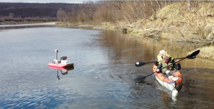
The impacts of ice-covered and open-channel flow on sediment load at sub-arctic river
The ongoing climate change is prone to alter the seasonal hydrology and the duration of ice-covered conditions in Northern rivers. The impacts of changing river flow conditions on annual and seasonal sediment loads are estimated with hydro- and morphodynamic model. The seasonal channel forms, material transport and morphodynamics are investigated by applying photogrammetric analyses (of under- and above water morphodynamics) and a variety of fluvial measurements (such as flow velocity, discharge, material transport and river ice characteristics). A low-cost shallow-water-AUV (Autonomous Underwater Vehicle) is used for photogrammetric analyses of ice-covered and open-channel forms and sediment transport to enhance the model. The model will be further tested against catchment-based models and applied at other river systems, which enhances the predictions of river flow conditions and sediment loads in the future.
Contact: Virpi Pajunen, Eliisa Lotsari and Juha-Matti Välimäki, University of Eastern Finland
Surface flow velocities in river channels and influence of hydropeaking on river network
A joint monitoring campaign is done in Kalajoki to test usability of drone-based video analysis to study surface flow velocities in river channels. This new spatially coverage measurement technique could be used to map large spatial areas in rivers as part of normal monitoring campaigns in the future.
Contact: Hannu Marttila, University of Oulu & Eliisa Lotsari, University of Eastern Finland
Seamless river channel topography
Seamless river channel topography mapping has been challenging, as most laser scanning systems do not get data underwater due to water absorption on used lidar wavelengths, and sonar has difficulties in shallow waters. Typically, any underwater measurements with sonar or current profilometers are conducted as a separate measurement campaign, and above water topography is measured separately. Now we are combining all sensors into a common platform for simultaneous and locally consistent data. Also, airborne multi-wavelength laser scanning data will be collected to test the feasibility of seamless river channel mapping, with the advance of possibilities for automated land cover classification based on the different wavelengths.
Contact: Harri Kaartinen, FGI & Petteri Alho, University of Turku
Water quality monitoring with passive samplers and high frequency sensors
DGT® passive samplers have been tested in small agricultural streams in Eurajoki and in the Ruukki test site to monitor dissolved reactive phosphorus during April and May 2021. The Ruukki site represents cultivated peatland and the Eurajoki site covers clayey soil fields. Additional experiments are possible during the project.
New high frequency Trios Opus sensors are tested in Oulanka and Ruukki sites for multispectral dissolved organic carbon (DOC) and nitrate analysis. Later, sensor data is connected to catchment scale modelling for better understanding the processes influencing the changes.
Contact: Maria Kämäri, SYKE & Hannu Marttila, University of Oulu
Automatic quality control of high frequency sensors
Online water quality measurements in the field are getting more and more common, but questions related to data reliability are hindering their wider adaptation. An automatic measurement uncertainty estimation system based on replicate measurements and certified reference materials will be tested in Pitkäkoski in the Vantaanjoki River.
Contact: Joonas Kahiluoto, SYKE
Uncertainty and Artificial Intelligence in water quality monitoring
Understanding uncertainty of different water quality monitoring techniques helps to improve more efficiently quality of our lakes and rivers. Today people are using a variety of monitoring techniques to monitor surface water quality directly or indirectly using satellites, drones, moving ships, automatic stations, water samples or citizen observations. To be able use this heterogenous data and see faster impacts of different human actions, like restoration or new fish farms, there is a need to better understand uncertainty of these data sources both spatially and temporally. Project studies uncertainty of different measurement technologies to be able to combine and complete data using developed data fusion techniques for water quality parameters like chlorophyll and turbidity.
Artificial intelligence (AI) can be used to forecast floods anywhere, anytime and by anybody to improve safety one day. Record flood magnitudes and increased flood frequencies are commonly attributed to profound anomalies and changes in the climate. Thus, it is important that we are studying emerging novel sensing, communication, and AI technologies potentially suitable to address future flood forecasting challenges. AI can learn in groups, and it has a good memory, but how to use it?
New multimodel approach containing hydrodynamical, habitat, energy market and economical models are built and tested in River Kuusinkijoki to study influence of hydropeaking on river network and environment, and to find sustainable ways to combine different interest in water management.
Contact: Jari Silander, SYKE & Hannu Marttila, University of Oulu
Urban flood risk management
SYKE has produced a Preliminary Pluvial Flood Map to help municipalities and rescue services to assess the risk. It shows the potential flood hazard areas caused by heavy rain for two rain events. For cities and residential areas, these require accurate simulation of the surficial water flow in a built environment.
To this end, the KM2 digital elevation model (DEM) needs to be carved (especially through roads) to allow water flow through routes that are not visible in the DEM, such as culverts and some bridges. There are already methods developed to locate culverts with the help of auxiliary data, but not all of them are found. In an independent study, an algorithm was developed to automatically detect culverts. The testing was conducted on a rural study area that was intersected by a highway and smaller roads. In this work, we study the applicability of the automatic culvert detection algorithm in a built environment and assess its accuracy.
Contact: Ville Mäkinen, Mikko Huokuna and Mikko Sane, SYKE