Freshwater Competence Centre scientists celebrate the World Water Day in the field
Today is World Water Day, which is an important day for the Freshwater Competence Centre.
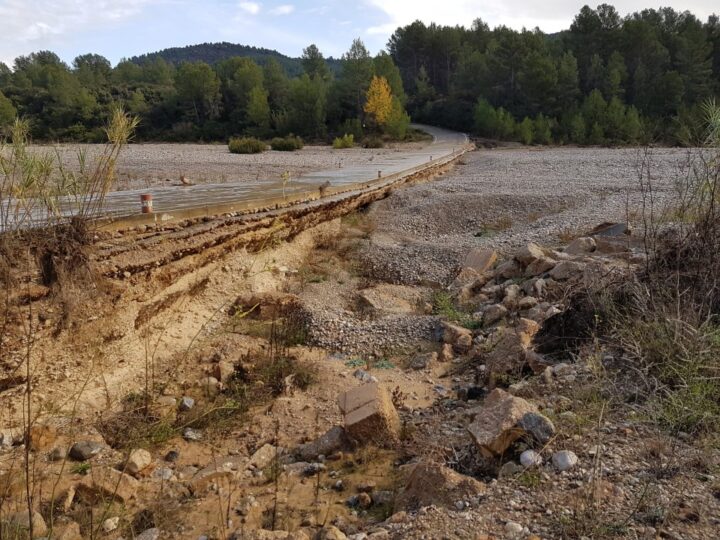
Our researchers from Finnish Geospatial Research Institute FGI and University of Turku, are currently in Spain conducting measurements on the Rambla de la Viuda river, which experiences severe flash floods annually. Our local partner, the Complutence University of Madrid, is assessing the flood’s intensity, duration, and sediment transport using permanent sensors. These measurements aim to improve the prediction of flood impacts. “The flash floods have an effect on the geomorphology of the area, but the true extent of these impacts is not well known yet”, explains Professor Petteri Alho from University of Turku. “Long time series are therefore very important, they give us valuable knowledge, and we have been collecting data in the area since 2012”.
A drone and a backpack laser scanner from the Finnish Geospatial Research Institute FGI have been transported to the area this week. The backpack laser scanner helps cover blind spots in the drone measurements. These systems are among the most precise globally and enable the three-dimensional modeling of the river sediments and banks. “The sensor technology from Finnish Geospatial Research Institute FGI is unique on the global scale, they allow very precise, 3-dimensional mapping of the sediments and river banks. University of Turku and FGI cooperation actually produced the first ever mobile laser scanning in a fluvial environment in 2009” Professor Alho continues.

Harri Kaartinen is a research professor at the FGI, and has been conducting mobile laser scanning in fluvial environments for more than a decade. He walks in the Rambla de la Viuda with a backpack laser scanner, to map the small details carved in the solidified gravel by the floods, that the drone cannot reach. He tells, that the measurement methods used in Spain can also be applied to Finnish rivers, although they have constant flow of water in the channel and are not drying up between floods. For this reason, measurements in Finnish rivers utilize for example robotic boats, underwater drones and aerial laser scanners that can measure riverbeds through the water column.
FGI’s Research Professor Antero Kukko is in Spain flying the drone. He has plenty of experience flying in challenging conditions, he spent last winter in a research station in Antarctica, laser scanning snow and ice surface. He and Harri Kaartinen have been traveling the world for years, doing top research with the sensor systems that they develop themselves in Otaniemi, Espoo. Professor Petteri Alho from Turku and Post Doc researcher Mikel Calle Navarro from Complutense University of Madrid are experts in the geomorphology, dynamics of the river sediments. Mikel Calle Navarro completed a PhD regarding this topic, and has published a scientific article about the research in the Rambla de la Viuda.
The studies are part of the Green Digi Basin project and Digital Waters flagship, funded by the European Union – NextGenerationEU and the Research Council of Finland.
You can read more about this flood research in the following research articles:
Calle, Mikel; Lotsari, Eliisa; Kukko, Antero; Alho, Petteri; Kaartinen, Harri; Rodriguez-Lloveras, Xavier; Benito, Gerardo, Morphodynamics of an ephemeral gravel-bed stream combining Mobile Laser Scanner, hydraulic simulations and geomorphological indicators. 2015, Zeitschrift für Geomorphologie.
Lotsari, E. S., Calle, M., Benito, G., Kukko, A., Kaartinen, H., Hyyppä, J., Hyyppä, H., and Alho, P.: Topographical change caused by moderate and small floods in a gravel bed ephemeral river – a depth-averaged morphodynamic simulation approach, Earth Surf. Dynam., 6, 163–185, https://doi.org/10.5194/esurf-6-163-2018, 2018.