Can hydrodynamic phenomena in the depths of a river be measured from a drone?
Article image: Eliisa Lotsari https://onlinelibrary.wiley.com/doi/epdf/10.1002/esp.5853
Wouldn’t it be easy to do measurements and collect reference data for the hydrodynamic models with a drone? Instead of making ones’ way to the banks of the straight and meandering parts of the rivers, often by foot, and conducting physical measurements about the velocity of water, the surface level and topography.
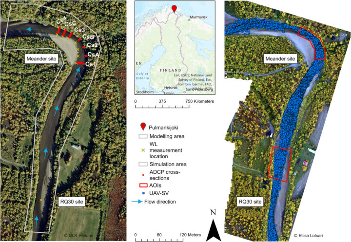
Our associate professor from Aalto University, Eliisa Lotsari, collaborated with Franziska Wolff from University of Eastern Finland and three scientists from University of Dresden to see how well the UAV-measured hydrological features correspond to the reference data – to the real-life hydrodynamics measurements and to the results from a 2D-hydrodynamic model that they built. “Measurement are usually conducted with traditional devices such as ADCP (AcousticDoppler Current Profiler) for velocity measurements and Laser scanners or RTK-GNSS systems (Realtime Kinematic Global NavigationSatelliteSystem) to acquire topography data.” The scientists write in their article.
Read the whole scientific publication here at: https://doi.org/10.1002/esp.5853
The scientists tested calibration of the model results in different ways and the conversion of the surface velocities that the drone measures into depth-averaged measures that estimate the flow of water in the vertical water column – and vice versa, from depth-averaged velocities from the 2D hydrodynamic model to surface velocities. Basically – if one has the actual measurements from the whole column, it’s nice to know if one can estimate the surface flow based on them, or if the only data available is drone image from the surface, how well can we calculate how the water moves in the depths?
There are many things and lots of local information to take into account regarding the input values and parameters that the model is given – for example regarding the roughness of the river bed and banks, that play an important role in the water level and flow velocity of the water.
The results were encouraging – The model showed good performance in the three calibration runs for water level and depth-averaged velocity. The calculation of surface to depth-averaged velocity indicated a good agreement between converted velocity and the reference data – for the straight river reach. A poor agreement, however, was evident for the meander section – the hydrodynamics are more complicated to model in the curvy parts of our rivers!

Reference:
Wolff, F., Lotsari, E., Spieler, D., Elias,M. & Eltner, A. (2024) Enhancement of two-dimensionalhydrodynamic modelling based on UAV- flow velocity Surface Processes and Landforms,1–15. Available from: https://doi.org/10.1002/esp.5853